Sat-Sight
Sat - Sight
Repos
dj-ryan/sat-sight (github.com) dj-ryan/sat-sight-view (github.com)
links
Calculations
Datasets
dataset - HYG dataset -Yayle Bright star
Rust
Organizing code & project structure - Rust Development Classes
Formulas
Haversine formula in Python (bearing and distance between two GPS points) - Stack Overflow mapping - Converting from longitude\latitude to Cartesian coordinates - Stack Overflow Hash Functions and list/types of Hash functions - GeeksforGeeks Program for distance between two points on earth - GeeksforGeeks
Godot
Can't get set_instance_color to work on my MultiMesh instances - Help - Godot Forum gdscript - Take screenshots in Godot 4.1 Stable - Stack Overflow Using signals — Godot Engine (stable) documentation in English File paths in Godot projects — Godot Engine (stable) documentation in English
Other concepts
OpenCV concept: Star Recognition Using Computer Vision (OpenCV) : 11 Steps (with Pictures) - Instructables 36698054.pdf ntrs.nasa.gov/api/citations/20200001376/downloads/20200001376.pdf
Computer Vision
Angle to Pixel
Visual Angle - Fast, Accurate, Reliable Eye Tracking
Great circle calculations
Great-circle distance - Wikipedia mathematics - Comparing angles and working out the difference - Game Development Stack Exchange
spherical geometry - Compute angle between two points in a sphere. - Mathematics Stack Exchange
Vulkan - rust - ash
Stereographic projection
Stereographic projection - Wikipedia
geometry - Stereographic Projection from an Arbitrary Point - Mathematics Stack Exchange Gnomonic projection - Wikipedia
arXiv:astro-ph/0207413v1 19 Jul 2002 Gnomonic Projections of Polycra | Desmos LAMBDA - IRAS Maps Coordinate Projections Details
22. Gnomonic projection | Eu, Mircea
FITS
How to Use FITS Images...and What are They? • PhotographingSpace.com
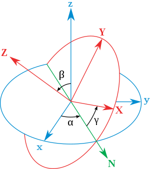
Standard notations
Latitude - λ (lambda, Greek L) - Rotation around the X axis - y on cartesian - Range: (-90,90) Longitude - φ (phi, Greek F) - Rotation around the Y axis - x on cartesian - Range: (0,360) Heading/Orientation - θ (theta, Greek T) - Range: (0, 360)
- 𝛼
(or 𝜑
) is the signed angle between the x axis and the N axis (x-convention – it could also be defined between y and N, called y-convention).
- 𝛽
(or 𝜃
) is the angle between the z axis and the Z axis.
- 𝛾
(or 𝜓
) is the signed angle between the N axis and the X axis (x-convention).
Star-print ideas
- Blur the image, sum pixel values where stars should be
- Create pairs of stars for the whole image and use them as vectors
sat sight view
Screenshots dir: C:\Users\golia\AppData\Roaming\Godot\app_userdata\Sat-sight-view\screenshots
Window size: 648px x 648px
With an orthogonal view, changing the
Size of star - changes star size
Size of universe - changes density
Azimuth coordinates are based on the observer's position on Earth and move with the Earth as it rotates and orbits the sun. Equatorial coordinates are independent of the observer's position and always point in the same direction in the sky. Stellarium Web Online Star Map
Vector
| x | y | z | ? |
|---|---|---|---|
| + | + | + | Nope |
| - | + | + | Right orientation, wrong position |
| - | + | - | Nope |
| + | + | - | Very close... |
| + | - | + | Nope |
Data parse Site Unreachable
1,4,HR|5,10,Name|15,11,DM|26,6,HD|32,6,SAO|38,4,FK5|42,1,IRflag|43,1,r_IRflag|44,1,Multiple|45,5,ADS|50,2,ADScomp|52,9,VarID|61,2,RAh1900|63,2,RAm1900|65,4,RAs19000|69,1,DE-1900|70,2,DEd1900|72,2,DEm1900|74,2,DEs1900|76,2,RAh|78,2,RAm|80,4,RAs|84,1,DE-|85,2,DEd|87,2,DEm|89,2,DEs|91,6,GLON|97,6,GLAT|103,5,Vmag|108,1,n_Vmag|109,1,u_Vmag|110,5,B-V|115,1,u_B-V|116,5,U-B|121,1,u_U-B|122,5,R-I|127,1,n_R-I|128,20,SpType|148,1,n_SpType|149,6,pmRA|155,6,pmDE|161,1,n_Parallax|162,5,Parallax|167,4,RadVel|171,4,n_RadVel|175,2,l_RotVel|177,3,RotVel|180,1,u_RotVel|181,4,Dmag|185,6,Sep|191,4,MultID|195,2,MultCnt|197,1,NoteFlag
conversion of polaris
| α UMi A | |
|---|---|
| Right ascension | 02h 31m 49.09s[2] |
| Declination | +89° 15′ 50.8″[2] |
| RA DEC flexible converter | |
| (accuracy ~ 1e-4 deg ~ 5 mas, J2000.0, galactic coordinates) | |
| 123.2805417 26.4613966 |
| HR | Name | GLON | GLAT | Vmag |
|---|---|---|---|---|
| 424 | 1Alp UMi | 123.28 | 26.46 | 2.02 |
Concepts
Euler angles
Spherical Cords

Lat & Lon
